- Alumna
changes face of archeology
By Christine Palm
How does a classics major end up designing high-tech instruments for archaeological digs? Why would an expert violinist choose to make her mark in the field of ground-penetrating radar? And by what means does one go from “tray-sledding” outside a dorm to unearthing an elite ancient Roman villa along the Tiber?
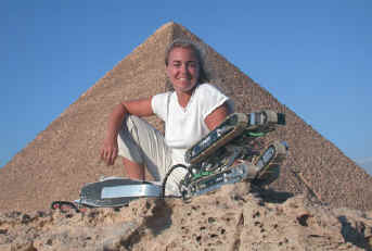
If one is Margaret “Meg” Watters, ’90, such a journey begins with a liberal arts education at Trinity College and takes you, among other places, down the 4,500-year-old shaft of a queen’s chamber of the Great Pyramids at Giza; to an Etruscan settlement in Spannoccia, Italy; back to the 17th century and the First Settlers’ Cemetery in Newbury, Massachusetts; to an Inca settlement in Peru; and even to Bellfield, the Hyde Park, New York, home of Franklin D. Roosevelt. It also takes you—remarkably enough—to the top of your field.
Since graduating from Trinity with a self-designed major called “studies in the ancient world,” Meg Watters has become renowned in the field of non-invasive archaeological mapping. Watters, a Ph.D. candidate at England’s University of Birmingham who holds an M.A. in archaeology from Boston University, designs and uses high-tech instruments that aid archaeologists without destroying the earth’s surface. Professionals ranging from museum curators to corporate executives to producers of National Geographic specials rely on her extensive knowledge of non-invasive mapping.
“Archaeology is inherently destructive,” Watters explains. “Once we excavate a site, it is destroyed. This destructive act is justified only if the site is excavated correctly, with artifacts and soils being processed, preserved, and written about in a timely manner. However, this is rarely the case, and too often a site is destroyed when these other, non-invasive, methods of exploring are available.”
Enter Watters’ nontraditional, and increasingly valuable, techniques of “reading” a site before any digging takes place. “I specialize in geophysical applications in archaeology, which means that I’ve got a bunch of equipment that I drag over the ground, poke into the ground, and hammer on the ground. These tools map the contrasting properties of the earth’s subsurface. Meaning that if something is buried in the soil that has different properties (electrical, chemical, magnetic, etc.) it can be mapped through one of the various techniques we employ to ‘read’ and draw a picture of what’s down there.”
Sounds simple enough. Except that Watters, who is apt to get good hunches about stuff buried many meters below the earth’s surface, discovered that a lot of the gizmos she needed didn’t exist. So, she invented them and convinced other people to manufacture them. She is fluent in a scientific language that involves machines called FM36 Fluxgate Gradiometers and G858 Cesium Vapor Magnetometers. And yet she has a classics major’s perspective on not just how these things are made and used, but why.
“We in the United States live in a very high-tech, fast-paced, competitive, and goal-oriented society,” she says. “We tend to forget where we have come from, who our ancestors are; how, in fact, we have come to such an advanced state. Knowledge of our past—our cultural heritage—is key in knowing who we are. It’s important to study the past through nonprejudiced means (or as close as we can get)—and archaeology is the closest I have come. In the end, I’m interested in knowledge, preservation, and education. I believe all the work we do should be available to the public, and that we should create nonacademic resources so that people don’t need to know the lingo in order to understand what we’re saying.”
The last thing we need is another fully excavated Roman villa
Given the exactitude of Watters’ work, many of her “maps” are local in scale. “If you excavate an entire area that’s 100 meters by 100 meters, that’s huge! It would take a very long time and be very expensive. Typically in archaeology, we do a ‘random sampling,’ where we dig holes about .5 by .5 by .5 meters—small shovel test pits over about 10 percent of the site. This is a hit-and-miss method of actually finding out what’s on the site. In fact, you could miss everything. On the other hand, I can map the same area in a day or two and tell you, ‘Over here is a villa; over here is the theater, or temple; over here there appear to be no significant archaeological features.’
“That way, if you are interested in Roman theaters, for example, you go and select a particular area to begin excavations. The theater may be only about 20 by 30 meters, but I can tell you where the front door is, the stage, etc. So then you can refine your interests even more. If you are studying the backstage area of theaters, you know where to go dig. If you are studying a Roman villa, it has areas that are public, others that are private, areas used for economic or religious reasons, and so on. They have baths, kitchens, female and male quarters, and at times, servants’ quarters. If you are particularly interested in the baths of rural farm villas, then you only have to dig so much, and I can tell you where to dig. Lord knows the last thing we need is another fully excavated Roman villa!”
Conversely, she is also involved in larger-scale, non-invasive site investigations through analysis of aerial photographs, satellite images, and micro-topographical maps.
“Larger scale investigations through remote sensing techniques enable large regions to be considered,” Watters says. “I can look at an aerial photograph and see crop marks that outline a Roman villa in the English countryside. Crop marks form when something like a stone foundation, a pit, or a path inhibits or enhances the growth of grass or a crop. Thus, some grass is longer and some grass is shorter in the same field. I can analyze this and interpret it as being either archaeological or geological in nature. Or I can see a region and with analysis be able to comment on land use and alteration by human or natural means.”
While at Trinity, Watters had no idea she would one day be among a handful of people—and one of only two women—doing such work. “My time at Trinity was spent studying the classics, playing my violin with different groups, theater productions, making some very close friends, and basically becoming a stronger, more confident person,” she recalls. “To be honest, I wasn’t into the sciences. Not at all. Nada. But I spent a semester abroad in Rome at the Intercollegiate Center for Classical Studies and it impressed me. That was the first clue that I liked archaeology.”
In the final analysis, Watters believes the greatest gift her Trinity education provided was a very simple, but critical one needed by scientist and classicist alike: “My liberal arts education gave me something essential—the ability to solve problems. In the end, it helps me with what I think is just the most amazing thing—to discover something that has been buried and forgotten for thousands of years. I’m always learning new things. It’s a great life.”